
.png)
Services
From inspections to imagery, we provide fast, safe, and accurate drone solutions tailored to industrial needs. Explore our core services below and see how we help you work smarter from above.


Inspection Services: Our drones deliver detailed inspections of external and confined-space assets—including towers, stacks, bridges, tanks, and vessels—quickly and safely, without scaffolding, shutdowns, or confined-space entry. We capture critical data to identify damage, wear, or anomalies early while reducing risk and downtime.

Click to View Portfolio
Click to View Portfolio

Cleaning Services: Efficient exterior building and window washing performed using drone-mounted pressure-washing systems. This method eliminates the need for scaffolding, lifts, or rope access while reducing risk, labour costs, and operational disruption. Ideal for high-rise facades, glass, cladding, and other hard-to-reach surfaces.


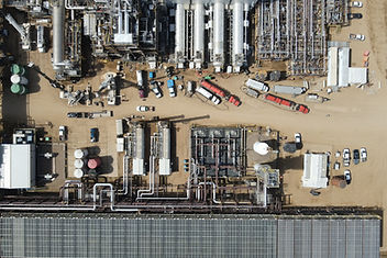
Mapping & Surveying: We generate accurate orthomosaic maps, 2D/3D models, and terrain data using photogrammetry and RTK workflows. Ideal for construction planning, asset management, and infrastructure development, our drone surveys are faster and safer than traditional ground methods.


Volumetric Analysis: Using drone-captured data, we calculate precise volumes of stockpiles, aggregate yards, and excavation sites. These insights support better inventory control, billing accuracy, and progress tracking without interrupting daily operations.

Click to View Portfolio
Click to View Portfolio

Thermography: Our thermal-equipped drones detect heat loss, electrical faults, moisture intrusion, and equipment overheating in real time. From solar farms to substations and rooftops, we help identify issues that are invisible to the naked eye—before they become serious failures.

Imaging & Visual Documentation: We deliver cinematic-quality visuals for industrial site documentation, project marketing, and construction progress tracking. Whether you need crisp orthographic images or long-term timelapses, our drone footage is tailored to your goals and timelines.